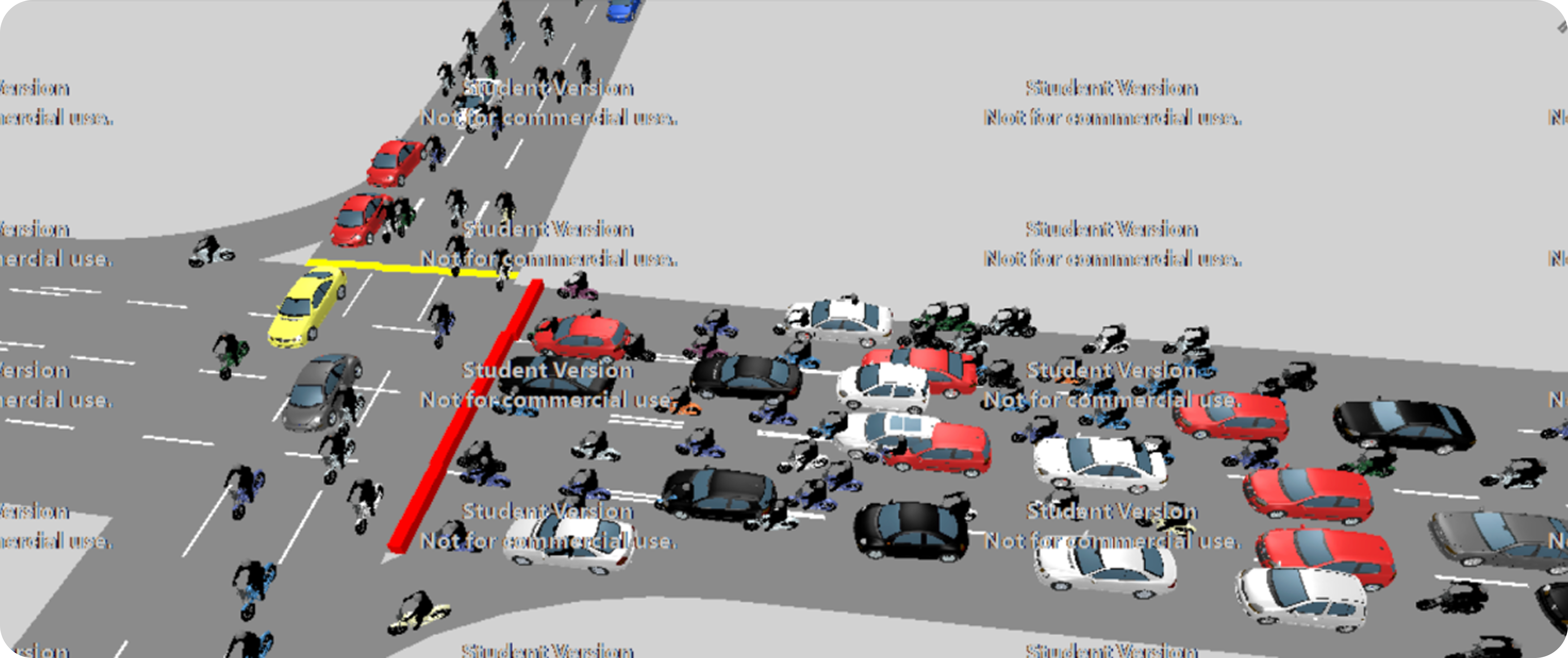
Traffic Impact Analysis Platform
Microsimulation to support data-driven transport decisions
Overview
This project used traffic microsimulation to evaluate the impact of a large mixed-use development in Bandung. Instead of relying on static formulas and assumptions, I modeled how vehicles and pedestrians actually move through intersections and road segments.
The goal was to help stakeholders make better decisions before construction, using data and simulation to test scenarios and avoid unnecessary or ineffective infrastructure changes.
Role: Data / Platform PM (Transportation Systems)
Scope: Urban road networks, intersections, pedestrian flows
Focus: Data modeling, scenario analysis, decision support
Problem
Traditional traffic impact analysis relied on fixed guidelines and averaged assumptions. These methods didn't account for real driving behavior, pedestrian interactions, or short-distance trips.
As a result:
- Congestion risks were often identified too late
- Solutions tended to overbuild infrastructure
- Costs increased without always solving the underlying problem
From a data perspective, the challenge was how to turn fragmented traffic inputs into insights that could actually support planning decisions.
Solution
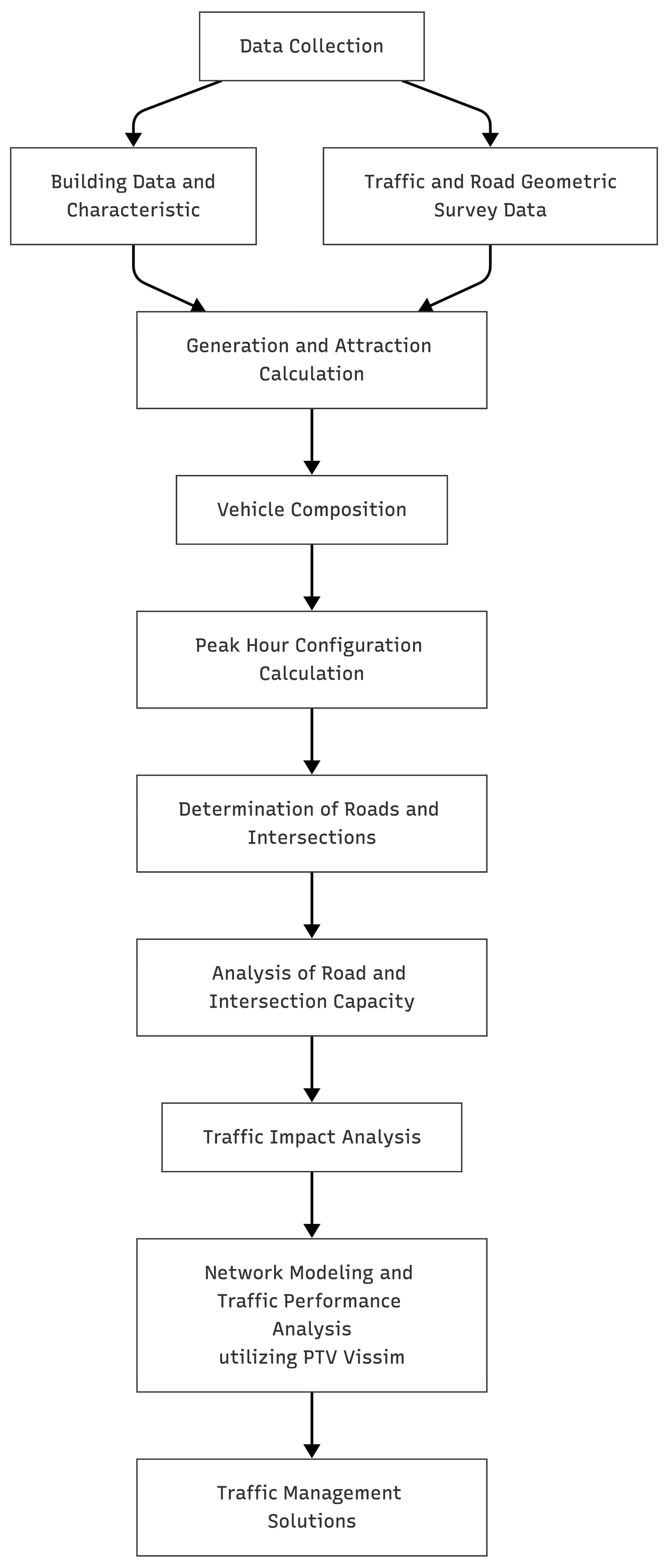
I built a microsimulation workflow using PTV Vissim to model traffic at a granular level.
The simulation combined:
- Road geometry and network layout
- Vehicle types and speed distributions
- Signal timing, routes, and pedestrian crossings
By running different demand and layout scenarios, I could compare outcomes and see where congestion would realistically occur, rather than where guidelines assumed it would.
Data & Modeling Approach
Instead of treating traffic as averages, the model simulated individual vehicles and pedestrians, each with their own behavior.
Key parts of the work included:
- Setting behavior parameters for lane changing, car following, and crossings
- Running multiple scenarios for current and future demand
- Calibrating the model using observed traffic data
- Validating outputs with statistical checks (e.g. GEH)
This helped ensure the simulation reflected real conditions closely enough to be useful for decision-making.


Network modeling: input of locations, road links, and connectors


Traffic modeling: input of vehicle types, speed distributions, routes, and signal controllers (including position, timing, and programs)
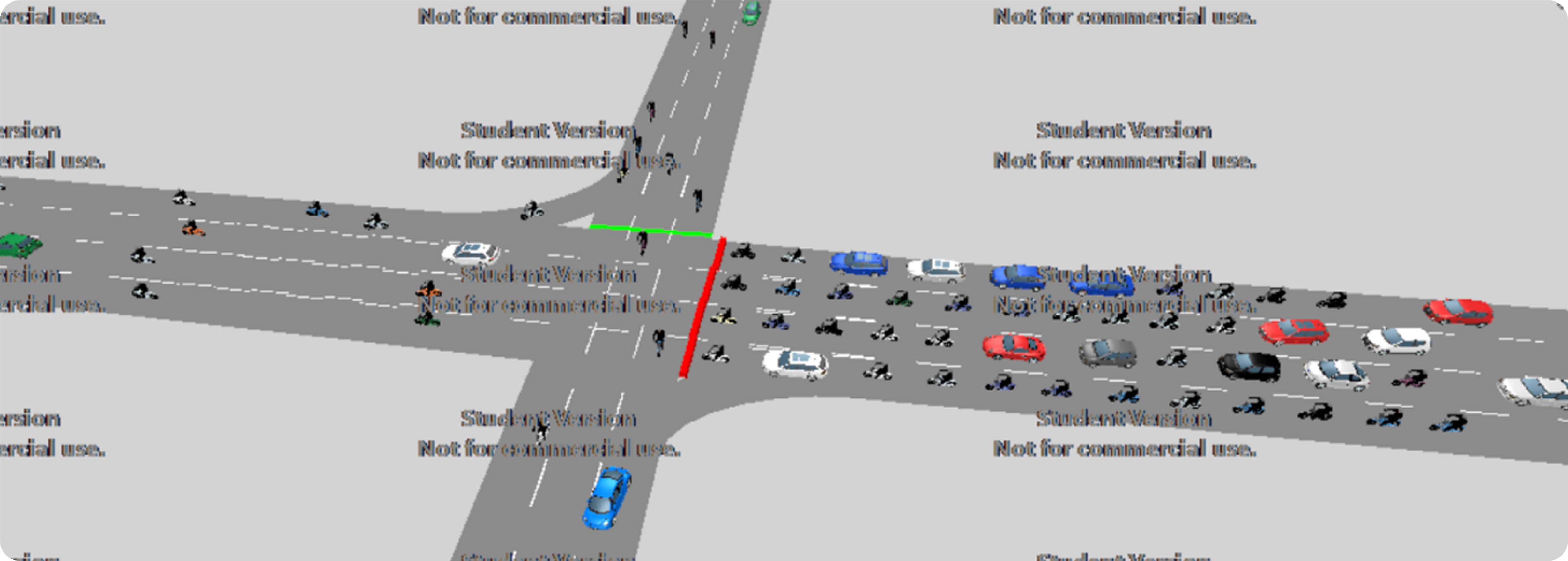
The model was calibrated to reflect local driving patterns, pedestrian activity, mixed vehicle types, and existing signal operations before running scenario comparisons.
Analysis & Insights
Running different scenarios surfaced issues that wouldn't have been obvious from static analysis. In particular, we identified specific intersections that would become bottlenecks as demand increased.
One key finding was that adjusting lane configuration improved capacity more effectively than widening roads. This approach delivered better flow while avoiding major construction.
What I Learned
Design decisions and data are tightly connected. Modeling different options early made it easier to compare alternatives and choose more effective solutions.
Skills & Capabilities
- Data modeling — translating raw traffic inputs into usable simulations
- Scenario analysis — testing alternatives and comparing outcomes
- Validation & calibration — checking models against observed data
- Decision support — turning complex outputs into clear recommendations
- Systems thinking — understanding large-scale, real-world user behavior
Keywords: data-driven decision making, simulation modeling, scenario analysis, validation, infrastructure planning, large-scale systems